
World money
Information site about world money

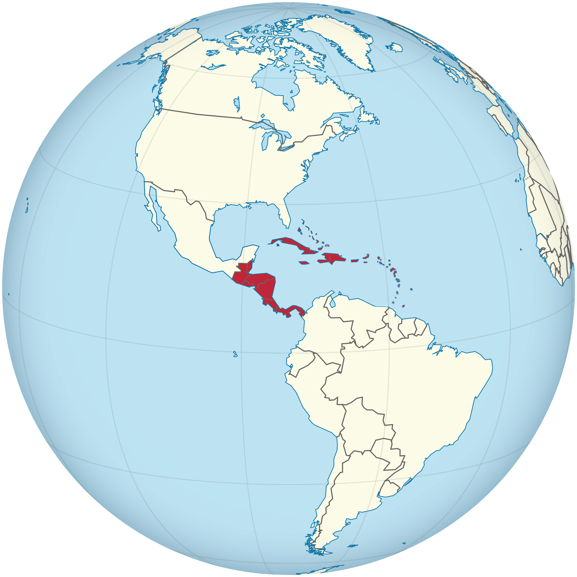
Central America is sometimes defined as a subregion of the Americas. This region is bordered by Mexico to the north, Colombia to the southeast, the Caribbean Sea to the east and the Pacific Ocean to the west and south. Central America consists of seven countries: El Salvador, Costa Rica, Belize, Guatemala, Honduras, Nicaragua and Panama.
Area: 521,876 km2
Languages: Spanish, English, Mayan languages, Garifuna, Kriol, and other.
Time zones: UTC -6:00 to UTC -5:00
UN M49 code: 013 – Central America
419 – Latin America
019 – Americas
Central America and Caribbean
The Caribbean is a region situated largely on the Caribbean Plate, the region comprises more than 700 islands, islets, reefs and cays. These islands generally form island arcs that delineate the eastern and northern edges of the Caribbean Sea. The Caribbean islands, consisting of the Greater Antilles on the north and the Lesser Antilles on the south and east (including the Leeward Antilles), are part of the somewhat larger West Indies grouping, which also includes the Lucayan Archipelago (comprising the Bahamas and Turks and Caicos Islands). The Lucayans and, less commonly, Bermuda, are also sometimes considered Caribbean despite the fact that none of these islands border the Caribbean Sea. In a wider sense, the mainland countries, regions, and territories of Belize, the Caribbean region of Colombia, Cozumel, the Yucatán Peninsula, Margarita Island, the Guyanas (Guyana, Suriname, French Guiana, Guayana Region in Venezuela, and Amapá in Brazil), are often included due to their political and cultural ties with the region.
Area: 2,754,000 km2
Land area: 239,681 km2
Ethnic groups: Afro-Caribbean, European, Indo-Caribbean, Latino or Hispanic (Spanish, Portuguese, Mestizo, Mulatto, Pardo, and Zambo), Chinese Caribbean, Jewish, Arab, Javanese, Amerindian, Multiracial.
Languages: Spanish, English, French, Dutch, French Creoles, English Creoles, Caribbean Hindustani.
Time zone: UTC-5 to UTC-4

Central America


Caribbean Region


Capital: Kralendijk Offic. lang: Dutch Area: 294 km2 Currency: US dollar ($) (USD) Time zone: UTC−4 (AST) Driving side: right Calling code: +599-7

Capital and largest city: Road Town Official language: English Area: 153 km2 Currency: United States dollar (US$) (USD) Time zone: UTC-4:00 (AST) Driving side: left Calling code: +1-284 ISO 3166 code: VG

Capital city: George Town Official language: English Area: 264 km2 Currency: Cayman Islands dollar (KYD) Time zone: UTC-5:00 (EST) Driving side: left Calling code: +1-345 ISO 3166 code: KY

Capital: Havana Offic. lang: Spanish Area: 109,884 km2 Currency: Peso (CUP), Convertible pesoa (CUC) Time zone: UTC−5 (CST), s−4 (CDT) Driving side: right Calling code: +53

Capital: Willemstad Offic. lang: Papiamentu, Dutch, English Area: 444 km2 Currency: Netherlands Antillean guilder (ANG) Time zone: UTC−4 (AST) Driving side: right Calling code: +599 9


Capital: Santo Domingo Offic. lang: Spanish Area: 48,671 km2 Currency: Peso (DOP) Time zone: UTC – 4:00 Driving side: right Calling code: +1-809, +1-829, +1-849

Capital: Gran Roque Area: 342 km2 Time zone: UTC-4:00 ISO 3166-2: VE-W


Country: France Official Language: French Area: 1,628 km2 Currency: Euro (€) (EUR) Time zone: UTC-04:00 (AST) ISO 3166 code: GPFR-GP

Capital: Port-au-Prince Offic. lang: French, Haitian Creole Area: 27,750 km2 Currency: Haitian gourde (G) (HTG) Time zone: UTC−5 (EST), s−4 (EDT) Driving side: right Calling code: +509

Capital: Kingston Offic. lang: English Area: 10,991 km2 Currency: Jamaican dollar (JMD) Time zone: UTC-5 Driving side: left Call.code: +1-658 (+1-876 active in November 2018)

Prefecture: Fort-de-France Official languages: French Area: 1,128 km2 Currency: Euro (€) (EUR) Time zone: UTC-04:00 (ECT) Calling code: +596 ISO 3166 code: MQFR-MQ


Area: 5.4 km2 Administration: USA

Country: Venezuela Capital: La Asunción Area: 1,151 km2 Time zone: UTC-04:00 (VET) ISO 3166 code: VE-O

Capital: San Juan Offic. lang: Spanish, English Area: 9,104 km2 Currency: United States dollar (USD) Time zone: UTC−4 (Atlantic) Driving side: right Calling code: +1-787, +1-939

Capital: The Bottom Offic. lang: Dutch Area: 13 km2 Currency: United States dollar (USD) Time zone: UTC−4 (AST) Driving side: right Calling code: +599-4

Capital and largest city: Gustavia Official language: French Area: 25 km2 Currency: Euro (€) (EUR) Time zone: UTC-4:00 (AST) Driving side: right Calling code: +590 ISO 3166 code: BLFR-BL

Capital: Basseterre Offic. lang: English Area: 261 km2 Currency: East Caribbean dollar (XCD) Time zone: UTC-4 Driving side: left Calling code: +1 869

Capital: Castries Offic. lang: Saint Lucian Creole, French Area: 617 km2 Currency: East Caribbean dollar (XCD) Time zone: UTC−4 Driving side: left Calling code: +1 758

Capital: Marigot Offic. lang: French Area: 53 km2 Currency: Euro (EU), US dollar Time zone: UTC-4 Driving side: right Calling code: +590

Capital: Kingstown Offic. lang: English Area: 389 km2 Currency: East Caribbean dollar (XCD) Time zone: UTC−4 Driving side: left Calling code: +1 784

Country: Colombia Capital: North End (San Andrés City) 12°33′N 81°43′W Languages: San Andrés Creole English, Spanish Area: 52.5 km2 Time zone: UTC-05 ISO 3166 code: CO-SAP

Capital: Oranjestad Offic. lang: Dutch Area: 21 km2 Currency: United States dollar ($) (USD) Time zone: UTC−4 (AST) Driving side: right Calling code: +599-3

Capital: Philipsburg Offic. lang: Dutch, English Area: 37 km2 Currency: Netherlands Antillean guilder (ANG) Time zone: UTC−4 (AST) Driving side: right Calling code: +1 721

Capital: Port of Spain Offic. lang: English Area: 5,131 km2 Currency: Trinidad and Tobago dollar (TTD) Time zone: UTC-4 (Atlantic Standard Time) Driving side: left Calling code: +1 (868)

Capital: Cockburn Town Offic. lang: English Area: 616.3 km2 Currency: United States dollar (USD) Time zone: UTC–5 (Eastern Time) Driving side: left Calling code: +1‑649

Capital city: Charlotte Amalie Official language: English Area: 346.4 km2 Currency: United States dollar ($) (USD) Time zone: UTC-4:00 (AST) Driving side: left Calling code: +1-340 ISO 3166 code: VIUS-VI